


Schlucht Hohneck

michelrenaud
User
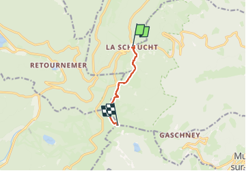

Length
4.7 km

Max alt
1355 m

Uphill gradient
235 m
Km-Effort
7.2 km

Min alt
1141 m

Downhill gradient
31 m
Boucle
No
Creation date :
2025-04-27 10:39:39.159
Updated on :
2025-04-27 15:32:28.338
4h33
Difficulty : Medium

FREE GPS app for hiking
 SityTrail
IGN / Geographical institutes
SityTrail Plus
The world is yours!
About
Trail Walking of 4.7 km to be discovered at Grand Est, Vosges, Le Valtin. This trail is proposed by michelrenaud.
Positioning
Country:
France
Region :
Grand Est
Department/Province :
Vosges
Municipality :
Le Valtin
Location:
Unknown
Start:(Dec)
Start:(UTM)
352712 ; 5325328 (32U) N.
Comments